With new advanced flood forecasting system, Bangladesh is set to strengthen disaster resilience
With new advanced flood forecasting system, Bangladesh is set to strengthen disaster resilience
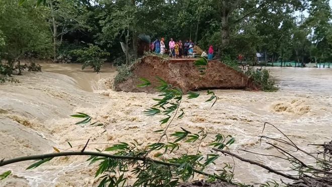
During the monsoon rain, in the rivers of Bangladesh, the flow of water is not the only thing that crosses borders. So do the lack of warnings. For years, Bangladesh has depended on India’s brief, last-minute alerts before upstream dams were opened.
“Though floodwaters take around seven to eight hours to reach Bangladesh, the short notice is often given at midnight, making timely preparedness difficult,” said Syeda Rizwana Hasan, adviser to the Ministry of Water Resources and the Ministry of Environment, Forest and Climate Change, while commenting on India’s last-minute floodgate warnings back in July this year.
That vulnerability which caused sleepless nights and panicked responses in flood-prone districts may soon become a story of the past. Bangladesh has taken a significant leap towards independence in its flood preparedness efforts by launching an advanced, data-driven Decision Support System (DSS) and entering a historic real-time data collaboration with the UK Met Office.
The new partnership with the UK is a crucial strategic turn. “We approached the UK Met Office, and they promptly agreed and signed an MoU,” Rizwana announced during Climate Week 2025, hosted by the Centre for Policy Dialogue (CPD) in Dhaka.
Riding on this collaboration, a new advanced flood forecasting system was rolled out in Bangladesh on 19 October. The collaboration gives Bangladesh access to real-time weather and flood forecasting data and something the country has long sought to build resilience against recurring disasters.
“Once we get access to the real-time data of the UK Met Office, learning how to translate that information before a disaster happens is also something they are going to support us with,” Rizwana said, noting the irony that a nation so frequently struck by floods had not yet developed its own real-time data collection mechanism.
This agreement follows the groundwork that culminated in July with the unveiling of Bangladesh’s upgraded Flood Forecasting and Warning Centre (FFWC) website and its new DSS. The event, held at the Bangladesh-China Friendship Conference Centre in Dhaka, symbolised a collective move towards a smarter, more anticipatory disaster management system.
The new Decision Support System (DSS) — how it works
Developed by the Regional Integrated Multi-Hazard Early Warning System (RIMES) in collaboration with the Bangladesh Water Development Board (BWDB) and funded through the World Bank’s CARE for South Asia Project, the DSS is the backbone of Bangladesh’s modern flood forecasting framework.
The system merges real-time hydrological, meteorological, and satellite data into a unified platform that issues early warnings and detailed visualisations. According to Nazmul Ahasan, country technical lead at RIMES, “The DSS prioritises usability, easy-to-understand warning information, user-specific analytics, and real-time alerts.”
“It also includes rainfall pattern analysis, system automation, and predictive models capable of generating warnings even in data-scarce regions,” he noted.
The main idea is the MIKE+ one-dimensional hydrodynamic model, linked to a rainfall-runoff module (MIKE+ RR), which simulates inflows from 247 catchments across Bangladesh. Covering 466 modelled rivers stretching over 21,990 kilometres, the system integrates data from 116 water level monitoring stations, each transmitting measurements at three-hour intervals between 6am and 6pm.
The DSS does not just crunch numbers; it visualises them. It offers rainfall distribution maps, river basin views (covering the Ganges, Brahmaputra, Meghna, and South-Eastern Hill systems), and flow path tools that trace how water moves across landscapes. Administrative boundaries from divisions to unions are overlaid on maps, enabling precise local analysis.
For public clarity, flood severity is colour-coded: Green means normal (more than 50 cm below danger level), Orange means warning (within 50 cm below danger level), Red means flood (above danger level) and Pink means severe flood (more than 1 m above danger level).
These levels are referenced to the Mean Sea Level (MSL), helping engineers and communities alike interpret flood data with accuracy.
Md Zohirul Islam, additional director general of BWDB, said, “The system marks a pivotal moment in improving flood preparedness and response.”
Nazmul Ahsan, secretary of the Ministry of Water Resources, reaffirmed the ministry’s commitment to citizen safety and data-driven planning.
“Since 2012, our collaboration with RIMES has helped develop advanced five-day deterministic, ten-day probabilistic, and fifteen-day long-range experimental flood forecasts for the Ganges-Brahmaputra-Meghna basin,” said Nazmul.
He highlighted that over 20,000 community members now receive actionable voice messages, a testament to expanding “last-mile connectivity” that brings technology directly to households in vulnerable regions.
The system’s integration with departments like Disaster Management, Agricultural Extension, Livestock Services, and the Department of Fisheries shows its relevance from protecting crops to safeguarding lives.
Raihanul Haque Khan, RIMES’ country programme lead for Bangladesh, identifies the DSS as the next step towards impact-based forecasting. “We are moving beyond hazard maps to identify the most affected areas,” he explained, adding that exposure indicators and community-tailored voice messages are already improving local preparedness. He also cited significant monetary savings in 2024 due to damages avoided through early warnings.
Human and environmental perspective
Rizwana Hasan said, “The DSS is more than just a water level prediction tool, rather it is a foundational pillar for building a holistic system of resilience, empowering communities with critical time for preparedness and decision-making.”
“We must move towards a smart approach to climate challenges,” she added, questioning the sustainability of infrastructure-heavy responses.
She also urged collaboration between the River Research Institute, RIMES, and FFWC to address river erosion, proposing the use of zonal inundation maps to expand predictive accuracy.
Push towards adaptation
Dr Abid Qaiyum Suleri, executive director of Pakistan’s Sustainable Development Policy Institute, who attended the Climate Week 2025 held a few days ago in Dhaka virtually, shed light on the funding gap. “In 2022, we had $10.8 billion pledged for disaster assistance, but only 25% of those pledges were materialised. Of that, only half a billion was grant.”
Md Shamsuddoha of the Centre for Participatory Research and Development shared similar frustrations. “We demanded trillions but found only around $760 million. Failure to limit global warming to 1.5°C would have catastrophic consequences for Bangladesh.”
Climate scientist Ainun Nishat added that, “Bangladesh produces less than 0.5% of global carbon emissions. Even if we triple our NDC, it will not matter. Mitigation is not Bangladesh’s headache. Bangladesh has to go for adaptation.”
The new flood forecasting system carries that very adaptation strategy. It combines technology, data, and community outreach to pre-empt disaster rather than merely react to it.
A.K.M. Tahmidul Islam, director general of BWDB, explained, “The system’s real-time data from 116 water level monitoring stations and detailed inundation maps will directly improve engineers’ field efficiency and operational decisions. The DSS translates innovation into action.”