
Dhaka: A city that built over its canals is now drowning in rain
Dhaka’s flooding crisis tells the story of a city that dismantled its own defences against rain
Dhaka: A city that built over its canals is now drowning in rain
Dhaka’s flooding crisis tells the story of a city that dismantled its own defences against rain
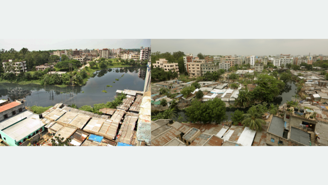
On 12 July, Dhaka received 76 millimetres of rain; over the next 24 hours, the total reached 97 millimetres. Mirpur, Mohammadpur, Dhanmondi, Bangshal, Jatrabari, Motijheel and Dholaikhal went under water.
Gulshan and Banani, the capital’s affluent neighbourhoods, were not spared either, perhaps the last form of equality the city still preserves.
Still, Dhaka’s HSC candidates sat for their examinations on schedule. Some waded through waist-deep water with admit cards wrapped in polythene.
But Dhaka was not designed to drown. That is not nostalgia; it is measurable geography.
The original city grew on the relatively high southern edge of the Madhupur Terrace beside the Buriganga. But the raised strip was surrounded and penetrated by floodplains, marshes, abandoned riverbeds, and seasonal lowlands.
Low-lying swamps extend into the city’s higher areas, including the Mirpur–Cantonment and Baridhara–Khilkhet–Uttara depressions.
The Bangladesh Institute of Planners describes a wider amphibious landscape made up of the Buriganga and its surrounding river system, natural canals, marshes, flood-retention areas, ponds, and seasonally inundated agricultural land.
These were not decorative features. They carried boats and goods, drained rainwater, stored floods and connected neighbourhoods to rivers. Historical accounts compared Dhaka with Venice; old maps show a city held together by water.
In 2012, Bangladeshi researchers Shahidul Islam, Shahabuddin, Mostafa Kamal, and Rakib Ahmed compared a 1960 government topographic map with a 2008 image taken by Japan’s ALOS satellite. Layering one over the other, they identified which blue lines had disappeared.
In 1960, Dhaka had nearly 3,000 hectares of rivers, canals and permanent water bodies, and about 13,500 hectares of low-lying flood-retention land. By 2008, the lowlands had shrunk to roughly 6,400 hectares — more than half gone.
The study, titled “Changes in Wetlands in Dhaka City: Trends and Physico-Environmental Consequences”, found that permanent water bodies fell by about 32.6% and lowlands by 52.6% between 1960 and 2008.
Another Landsat-based study found that Dhaka lost nearly 77% of its wetlands between 1978 and 2009.
More recent research, “Development at the Cost of Unsustainable Degradation of Wetlands”, estimated a 69% wetland loss between 1990 and 2020. It recorded surface water falling from 68.92 square kilometres in 2004 to 29.41 square kilometres in 2021, a 57.3% decline, while the once-connected network fragmented into isolated patches.
Different studies use different boundaries and definitions, so their percentages cannot be compared directly. But they all describe the same severe trajectory.
On the ground, the disappearance is even more visible. At the time of independence, Dhaka district still had 15 rivers. Five: the Aati, Konai, Dolai, Pando and Norai, are now missing.
Of 57 canals that existed after independence, only 26 survive. British-era Dhaka had about 120 ponds; only 24 remain.
Boats once travelled through the Dholaikhal into the Buriganga. Today, “Dholaikhal” means a market for used motor parts. A waterway survives only as an address for scrap.
These channels did not die naturally. Housing projects filled them, influential interests occupied them, and the state itself covered some with concrete to build roads and box culverts.
Beneath the traffic of Panthapath, for instance, lies the body of a canal. The water has returned to its home; the encroachers are us.
The state knew the consequences. Dhaka’s first drainage masterplan was prepared in the 1960s. In 1991, with support from JICA, Japanese engineers divided the city into 12 drainage zones and mapped how rainwater should move through canals into rivers. A further study followed with World Bank financing in 2011.
For six decades, the drawings have remained on tables: one plan in the 1960s, another in 1991, another in 2011. In every generation, the state buys a plan and then allows the canals in that plan to be sold.
The 1991 plan rested on a simple principle: in heavy rain, lakes and lowlands save the city. Water first spreads into retention areas, pauses there, then slowly drains through canals to rivers. In engineering language, these are retention spaces; in plain language, the city’s lungs. Later studies repeated the same warning: fill the lowlands and waterlogging follows.
Science identified lungs; the property market identified plots. Today, buildings and housing-project signboards stand where water was meant to wait.
Dhaka still has surrounding rivers, surviving canals, floodplain wetlands and water bodies. The 2021 assessment recorded about 29.4 square kilometres of surface water, roughly 9% of its metropolitan study area.
In 2026, the government was still identifying, demarcating and attempting to recover canals in Dhaka North and South. But much of what remains is smaller, disconnected, encroached, polluted, clogged with waste or cut off from rivers by roads and embankments.
The financial record is equally troubling. In only four years, Dhaka’s two city corporations spent at least Tk730 crore on waterlogging. WASA and the city corporations put spending over a decade at no less than Tk3,000 crore. Yet a city that could absorb 50 millimetres of rain an hour only two or three years ago now floods at around 35 millimetres.
It is a rare investment in which capacity falls as expenditure rises. Projects continue because, too often, the real product is not drainage but the project itself: tender, bill and share. Waterlogging has become not merely a problem but a business, with rain as its raw material.

Graphics: TBS
Responsibility was long blurred. The law assigned stormwater drainage to Dhaka WASA, which blamed the city corporations; the corporations blamed WASA. Transparency International Bangladesh wrote that agencies used legal ambiguity to shift responsibility while citizens paid the cost. WASA claimed 20 of its 26 canals were operational; field researchers found outlets blocked by waste.
On 31 December 2020, the canals were ceremonially transferred from WASA to the two corporations. Files moved from one table to another; the water stayed where it was.
The remedy is not unknown. Research indicates that excavating only 15 encroached canals could resolve about 80% of the city’s waterlogging. But excavation requires removing occupiers, and occupiers have names, parties and power. The real address of waterlogging is therefore not the road but the land deed.
Pollution makes the remaining lakes and canals even less useful. Sewage, industrial effluent, household waste and contaminated sediment turn storage spaces into stagnant reservoirs. Dredging or beautification alone cannot work while drains continue delivering pollution.
Other cities show that recovery is possible, but never through a one-off cleaning drive.
Singapore transformed the concrete Kallang River channel through Bishan–Ang Mo Kio Park into a winding river with floodable banks stabilised by rocks, vegetation and soil bioengineering. Planted wetlands filter runoff; in dry weather the floodplain is parkland, while in storms its lawns store and carry water.
Seoul removed about 5.4 kilometres of road and elevated highway to reopen Cheonggyecheon, recycling most demolition material. It rebuilt bridges, roads and sewers, gave the combined sewer roughly three times the estimated wastewater-flow capacity, designed for a 200-year rainfall event, reorganised traffic and expanded public transport.
Because natural flow is insufficient, Han River water and subway groundwater are pumped into the stream.
At the time of independence, Dhaka district had 15 rivers. Of them, five — Aati, Konai, Dolai, Pando, and Norai — no longer exist. Of the 57 canals that existed after independence, only 26 survive. British-era Dhaka had about 120 ponds; now only 24 remain.
Tokyo restored the Sumida through sewer expansion, treatment, industrial-discharge controls and decades of dredging, begun in 1958, to remove contaminated mud and sludge. Fish, birds and public life returned because pollution was stopped at source; dredging alone would have failed.
Copenhagen upgraded treatment plants, modernised sewers, built underground reservoirs and conduits, closed dozens of overflow outlets and uses sensors, computer models and temporary swimming closures.
After the destructive 2011 cloudburst, it redesigned roads, parks and canals as stormwater routes and storage, using tunnels where surface space is unavailable. Its premise is pragmatic: no city can prevent every flood, but it can keep water away from homes, hospitals and transport.
Rotterdam’s Benthemplein water square stores about 1.7 million litres while serving as a sports and community space when dry; green roofs, tanks, rain gardens and floodable parks follow the same principle.
Utrecht removed a road and replaced 12 traffic lanes with water and vegetation, reconnecting a historic canal after reorganising traffic. It shows reversal is possible, but expensive once structures occupy the waterway.
Dutch regional water authorities provide permanent responsibility and revenue for flood defence, water quantity and quality, waterways and wastewater treatment.
Seattle’s Lake Washington, once cloudy, foul-smelling and choked by phosphorus-fed algae, recovered after scientists traced the nutrient to sewage. A regional authority built more than 100 miles of interceptor and trunk sewers and diverted treatment-plant effluent between 1963 and 1968. The intervention happened mainly outside the lake, without relying on repeated chemical treatment or perpetual dredging.
Dhaka’s answer is therefore not a choice between cleaning lakes and reducing waterlogging. Lakes, canals, sewers, roads, pumps, wetlands and rivers form one hydraulic system.
The city must map every sewage, stormwater and industrial outfall; intercept sewage; control solid waste; test sediment before dredging; reconnect lakes, canals, retention areas, pumps and rivers; protect floodable land; and turn selected canal banks, parks, school grounds and plazas into temporary storage.
Promenades, cycleways, lighting, boating and commerce should come last. The strongest model would combine Lake Washington and Tokyo for pollution control, Singapore for canal floodplains, Copenhagen and Rotterdam for stormwater, and Dutch institutions for permanent management.
Dhaka does not lack plans. It lacks the political courage to recover the space already assigned to water. Until that changes, every heavy rain will continue to expose the same truth: the city is not being invaded by water. Water is reclaiming the city that was built over it.